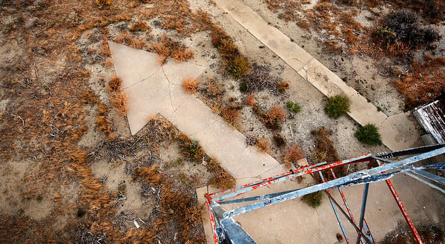
Giant arrows, which may reach 70 feet in length and are a forgotten vestige of a bygone era, are a mystery in America. But why did the US government have these massive markers built every ten miles all throughout the country?
In 1924, the federal government supported the construction of massive concrete arrows every 10 miles or so along established airmail routes to aid pilots in tracing their way across America in inclement weather, particularly at night, when flying was more efficient.
What are these Mysterious Giant Arrows Scattered Across the US?
There are strange concrete markings that have been seen all over America, leading hikers and travelers to wonder what they may possibly represent and where they are pointing. However, there are legends that enormous arrows, which may reach 70 feet in length, are a forgotten relic of a bygone era.
These massive arrows, strewn across scrubland and seemingly at random locations, were once markers for early airmail flights across the United States, constituting the world’s first land-based navigation system.
The solid concrete arrows were installed at the foot of illuminated beacons near airways to show pilots which way to fly to go to the next stop-off to carry mail. Airmail was first used in the United States in 1911, with the first official flight going from Petaluma, California, and arriving in Santa Rosa, California.
As the flights became longer and more frequent, beacons and arrows were added to aid pilots in their navigation. Following World War I, the US Postal Service began using surplus airplanes for mail delivery, with several of them being flown by former army pilots. (Source: Charismatic Planet)
The Process Of Making These Giant Arrows
In 1924, the massive arrows began to be placed across the country, at 10-mile intervals, on a regular basis. Furthermore, the intention was that the markers, which were painted bright yellow and positioned alongside a beacon with a gaslight at the top, could be seen for up to 10 miles, allowing pilots to find their route.
They stretched from Wyoming to Ohio in the summer of 1924, and by the following year, the arrows had reached New York. The arrows were able to direct planes all the way across America by 1929.
Following the yellow concrete trail, the major New York to San Francisco flight route spanned from New York to San Francisco. The arrows were used to ensure pilots could find their course even in bad weather in the days before radio and satellite connections.
Though the arrows have long been forgotten, with many lost forever, there are fans who have discovered one arrow or two in the countryside and are working on mapping the concrete markings that have been left behind.
Brian and Charlotte Smith, a retired couple, received an email that caught their interest and has been following the arrows ever since. (Source: Charismatic Planet)
The End of an Era: The Giant Arrows’ Legacy
Radio had become the dominant mode of communication by World War II, rendering airway beacons obsolete. The government demolished the skyscrapers and recycled the scrap metal for the war effort, taking whatever they could grab. It’s unclear how many airway lighthouses exist, but a preservation program called Passport in Time has saved three beacon locations from total decay, including the generator huts and a nearby 1930s cabin that functioned as the fire lookout’s apartment. (Source: Charismatic Planet)
