The Micronesians or Marshallese were able to build vessels known as outrigger canoes and develop their system of piloting and navigation centuries ago. Long before modern mapping and GPS, the Micronesian people relied on their ability to sense the motion of the waves for navigation. But did you know that they also navigated ocean swells?
Micronesians navigated the Pacific by recognizing and interpreting various types of ocean swells, even using them to pinpoint the existence of islands hundreds of miles away. Marshallese islanders also created stick maps of these ocean swell patterns.
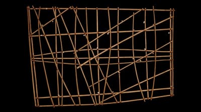
The Unique Navigation Technique
For thousands of years, Marshall Islanders used a complex form of navigation with charts made from coconut midribs and seashells. The charts were made up of curved and straight sticks. Straight sticks represented the currents and waves around the islands, while curved sticks represented ocean swells. The seashells represented the islands’ locations. The charts were memorized by the Marshallese navigators, who did not carry them in their canoes. Each chart was unique and could only be interpreted by the creator.
The Marshall Islands consist of 29 coral atolls and five individual islands. The islands and atolls are divided into the western Ralik chain and the eastern Ratak chain. The islands are extremely low in elevation and were not visible from great distances to navigators.
The Marshallese used star patterns to navigate the ocean in addition to wave and swell patterns. They also figured out where the islands were by watching the birds nest on their fly. Song was used to calculate the distance traveled by the navigators.
Stick charts were also created to depict major ocean swell patterns and how the islands disrupted those patterns. The shells tied to the framework or the lashed junction of two or more sticks represented island locations.
Archaeologists believe that the first people to settle the Marianas arrived after what may have been the longest uninterrupted ocean voyage in human history. (Source: Joys of Museums)
How was the Technique Passed On?
Pacific Islanders used the Stick Chart for Sea Navigation made of split reed and cowrie shells to help them navigate their ocean. The cowrie shells represent constellation stars.
Navigation techniques in the Marshall Islands were passed down from father to son. During the late nineteenth century, traditional navigation techniques began to decline. During the twentieth century, there were very few remaining Marshallese navigation experts. Korent Joel died in 2017 and was one of the last experts. Korent Joel, a cargo ship captain, collaborated with the Majel-based organization Waan Ael or Canoes of the Marshall Islands.
Through canoe building and sailing, the organization works to preserve Marshallese culture. Captain Joel used his partnership to teach Marshallese youth traditional navigation techniques he learned from his grandfather.
After World War II, new electronic technologies made navigation more accessible, and canoe travel between islands became less common. Nowadays, Marshallese stick charts are sold as souvenirs. The charts featured in this post were created around a century ago. (Source: Joys of Museums)
Image from SmartHistory