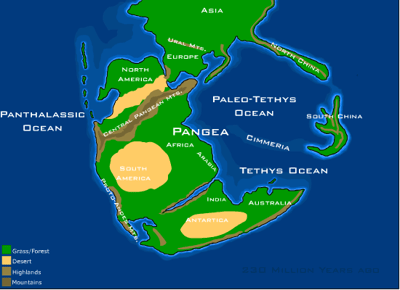
On a map of the Early Permian world, the familiar Atlantic gap is missing. West Virginia sits on the same joined landmass as what would become Europe and North Africa, and across the middle of that supercontinent runs a long northeast-to-southwest belt of mountains near the equator.[1]
The Scottish Highlands and the Appalachian Mountains are geologically linked as surviving pieces of the Central Pangean Mountains, a vast ancient range formed when the landmasses that became North America, Europe, and Africa collided during the assembly of Pangaea.
That old map makes a modern globe feel misleading. The Appalachians now belong to eastern North America. The Scottish Highlands sit across the Atlantic. But the ocean is the younger feature. The mountains came first, before North America and Europe were pulled apart by continental drift.[2]
The Central Pangean Mountains formed in the central part of Pangaea during the Carboniferous, Permian, and Triassic periods.[1] Their rise came from collision: Euramerica, also called Laurussia, pressed into Gondwana as the supercontinent assembled.[1] The result was not a local ridge, but a mountain system large enough to leave pieces across several modern continents.
At their greatest elevation in the early Permian, the Central Pangean Mountains were comparable in size to today’s Himalayas.[1] That scale is easy to miss now, because the best-known remnants are worn down, rounded, and separated by oceans. The surviving ranges are not the old peaks in full. They are the ruins.
The range the Atlantic divided
Several mountain-building episodes helped make the Central Pangean Mountains, including the Acadian, Caledonian, Alleghenian, Mauritanide, and Variscan orogenies.[1] The names are specialized, but the physical process is blunt: continents collided, crust folded and thickened, and a belt of mountains rose across the heart of Pangaea.
A list of the remnants reads like scattered clues. The Appalachian and Ouachita Mountains in North America are part of the old system, along with the Atlas and Anti-Atlas Mountains in Africa, and European remnants such as the Bohemian Massif and Massif Central.[1] Other accounts of the same ancient range point to Scotland, Scandinavia, Greenland, the United States, and Africa as modern fragments of the Central Pangean Mountains.[3]
The Scottish Highlands fit into that larger story through the Caledonian side of the collision history. One source describes the Highlands, parts of Norway, and Greenland as pieces of the Caledonian Mountains, while the later Appalachian mountain-building episode helped shape the North American side as Pangaea came together.[2] They are separated landscapes now, but their deep rock history belongs to the same continental assembly.
What happened to a Himalayan-scale range
By about 295 million years ago, at the beginning of the Permian, the Central Pangean Mountains had reached their maximum elevation after mountain building that began around 340 million years ago.[1] Then erosion began doing the quieter work.
During the Permian, intense physical and mechanical weathering reduced the peaks to roughly half their original size by the Late Permian and cut deep valleys between them.[1] By the Middle Triassic, the range had been substantially reduced. By the earliest Jurassic, around 200 million years ago, the western European part of the old Pangean range had become a few upland areas surrounded by deep marine basins.[1]
The mountains also left material behind. Sediments eroded from the Central Pangean Mountains contributed to vast coal beds in regions such as the Appalachians, where carbon-rich deposits formed from dense tropical forests of the time.[3] A range can be worn down and still remain underfoot.
So the odd fact is not simply that Scotland and Appalachia share a mountain story. It is that the Atlantic now fills the space where the connection used to be. On the old Permian map, there is no ocean crossing between those rocks, only one battered mountain belt running through the middle of Pangaea.